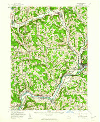
1956 Map of Owego
USGS Topo · Published 1960About this map
The Susquehanna River carves a deep valley through the southern portion of this mid-century Tioga County survey, defining the industrial and transportation corridor between Owego and Barton. The river's path, marked by features like The Narrows and Squaw Island, is shadowed by the infrastructure of the Erie Railroad and the Delaware Lackawanna and Western Railroad. Further north, Catatonk Creek provides a second vital corridor for the Lehigh Valley Railroad through settlements like Candor and Spencer. The map reveals a landscape of high ridges such as Candor Hill and Germany Hill, punctuated by remote rural institutions like Hamilton Sch and the Sulphur Springs Chapel. The density of named hollows and smaller settlements like Halsey Valley and Straits Corners offers a detailed view of the region's agricultural and social fabric before the expansion of modern highways.
Find a feature on this map
71 named features on this map. Tap any name to fly to it.
Don’t see what you’re looking for? This feature index may not catch every label — zoom into the map to look around manually.
Map Details
Editions of this 1956 Owego Map
This is the sole edition of this map. No revisions or reprints were ever made.
Other maps of this area

1893 · Ithaca
USGS Topo · 1:62,500

1895 · Ithaca
USGS Topo · 1:62,500

1900 · Dryden
USGS Topo · 1:62,500

1901 · Apalachin
USGS Topo · 1:62,500

1902 · Waverly
USGS Topo · 1:62,500

1903 · Owego
USGS Topo · 1:62,500

1903 · Harford
USGS Topo · 1:62,500

1904 · Apalachin
USGS Topo · 1:62,500

1905 · Watkins Glen
USGS Topo · 1:125,000

1906 · Catatonk
USGS Topo · 1:125,000