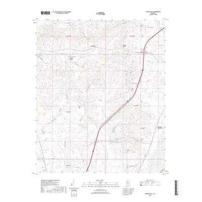
2018 Map of Owens Wells
USGS Topo · Published 2018About this map
Owens Wells serves as a focal point for this rural Holmes County landscape, situated near the headwaters of Tarrey Cr and Turrey Cr. The map reveals a dense network of country roads and family-named cemeteries, reflecting the generational settlement patterns of central Mississippi. Along the eastern corridor, the crossing of Interstate 55 creates a modern contrast to the older crossroads communities like West Hill and the former rail-associated Aberdeen Junction. The geography is defined by a series of south-flowing drainages including Box Cr, Bisland Bayou, and Big Cypress Cr, which carve through the terrain. Numerous historic burial grounds such as Gages Springs Cem, Sproles Cem, and Wesley Chapel Cem are scattered across the townships, providing significant data points for genealogists tracing local families in the areas surrounding Macedonia Ch.
Find a feature on this map
67 named features on this map. Tap any name to fly to it.
Don’t see what you’re looking for? This feature index may not catch every label — zoom into the map to look around manually.
Map Details
Editions of this 2018 Owens Wells Map
This is the sole edition of this map. No revisions or reprints were ever made.
Other maps of this area
1940 · Lexington
USGS Topo · 1:62,500
1953 · Meridian
USGS Topo · 1:250,000

1953 · Greenwood
USGS Topo · 1:250,000
1953 · West Point
USGS Topo · 1:250,000

1955 · Jackson
USGS Topo · 1:250,000

1956 · Greenwood
USGS Topo · 1:250,000
1957 · Meridian
USGS Topo · 1:250,000
1957 · Lexington
USGS Topo · 1:62,500
1958 · West Point
USGS Topo · 1:250,000
1958 · Lexington
USGS Topo · 1:62,500