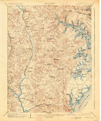
1905 Map of Owensville
USGS Topo · Published 1926About this map
Patuxent River and the meandering tributaries of the South River define the agricultural and maritime landscape of Anne Arundel County at the start of the twentieth century. This area is characterized by its reliance on water-based commerce, evidenced by the numerous landings and wharves such as Lees Wharf, Contees Wharf, and Hartges Wharf that dot the shorelines of the Rhodes River and West River. Inland, the settlement pattern centers on small post office villages like Owensville, Davidsonville, and Mt Zion, which served the surrounding farms.
Find a feature on this map
104 named features on this map. Tap any name to fly to it.
Don’t see what you’re looking for? This feature index may not catch every label — zoom into the map to look around manually.
Map Details
Editions of this 1905 Owensville Map
5 editions found

Other maps of this area

1892 · Laurel
USGS Topo · 1:62,500

1892 · Prince Frederick
USGS Topo · 1:62,500

1892 · Brandywine
USGS Topo · 1:62,500

1892 · Owensville
USGS Topo · 1:62,500

1892 · Annapolis
USGS Topo · 1:62,500

1893 · Sharps Island
USGS Topo · 1:62,500

1893 · North Point
USGS Topo · 1:62,500

1894 · Laurel
USGS Topo · 1:62,500

1894 · Relay
USGS Topo · 1:62,500

1895 · Prince Frederick
USGS Topo · 1:62,500