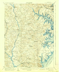
1905 Map of Owensville
USGS Topo · Published 1936About this map
Davidsonville and the tobacco-growing interior of Anne Arundel County are defined by their proximity to the deep tidal estuaries of the South River and West River in the early twentieth century. This survey reveals a landscape of dispersed agricultural settlements like Rutland, Birdsville, and McKendree connected by a network of landings and wharves. The economy of the era is evident along the shoreline at Hartges Wharf, Lees Wharf, and Steiners Wharf, where local produce met the waterborne trade of the Chesapeake Bay.
Find a feature on this map
105 named features on this map. Tap any name to fly to it.
Don’t see what you’re looking for? This feature index may not catch every label — zoom into the map to look around manually.
Map Details
Editions of this 1905 Owensville Map
5 editions found

Other maps of this area

1892 · Laurel
USGS Topo · 1:62,500

1892 · Prince Frederick
USGS Topo · 1:62,500

1892 · Brandywine
USGS Topo · 1:62,500

1892 · Owensville
USGS Topo · 1:62,500

1892 · Annapolis
USGS Topo · 1:62,500

1893 · Sharps Island
USGS Topo · 1:62,500

1893 · North Point
USGS Topo · 1:62,500

1894 · Laurel
USGS Topo · 1:62,500

1894 · Relay
USGS Topo · 1:62,500

1895 · Prince Frederick
USGS Topo · 1:62,500