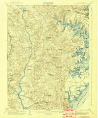
1905 Map of Owensville
USGS Topo · Published 1942About this map
Maritime trade and post-office settlements define the landscape of Anne Arundel and Prince George's counties at the turn of the century. The South River, Rhode River, and West River are bustling with activity, evidenced by a series of landings and wharves such as Lees Wharf, Contees Wharf, and Hartges Wharf. This period shows the reliance on both waterborne commerce and the developing rail networks, with the Chesapeake Beach Ry and Philadelphia Baltimore and Washington R R cutting through the countryside. Inland, the map documents small crossroads communities often identified by their dual names and post offices, such as Mt Zion Lothian P.O. and Butlers Harwood P.O.. These small hubs, along with landmarks like the Annapolis Waterworks, provide a granular look at rural Maryland life before the suburban expansion of the later twentieth century.
Find a feature on this map
94 named features on this map. Tap any name to fly to it.
Don’t see what you’re looking for? This feature index may not catch every label — zoom into the map to look around manually.
Map Details
Editions of this 1905 Owensville Map
5 editions found

Other maps of this area

1892 · Laurel
USGS Topo · 1:62,500

1892 · Prince Frederick
USGS Topo · 1:62,500

1892 · Brandywine
USGS Topo · 1:62,500

1892 · Owensville
USGS Topo · 1:62,500

1892 · Annapolis
USGS Topo · 1:62,500

1893 · Sharps Island
USGS Topo · 1:62,500

1893 · North Point
USGS Topo · 1:62,500

1894 · Laurel
USGS Topo · 1:62,500

1894 · Relay
USGS Topo · 1:62,500

1895 · Prince Frederick
USGS Topo · 1:62,500