
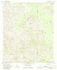
1962 Map of Owl Creek
USGS Topo · Published 1963About this map
Bogue Chitto Indian Sch serves as a prominent landmark in this 1962 landscape along the border of Neshoba and Kemper counties. The region is defined by a dense network of spiritual and educational centers, including Choctaw Ch, Macedonia Ch, and the Long Dale Sch. Small agricultural settlements like Forestdale and Crossroads are situated among the winding headwaters of Bogue Chitto and Coffadeliah Creek.
Find a feature on this map
36 named features on this map. Tap any name to fly to it.
Don’t see what you’re looking for? This feature index may not catch every label — zoom into the map to look around manually.
Map Details
Editions of this 1962 Owl Creek Map
2 editions found
Other maps of this area

1953 · Meridian
USGS Topo · 1:250,000

1957 · Meridian
USGS Topo · 1:250,000

1962 · House
USGS Topo · 1:24,000

1962 · Lynville
USGS Topo · 1:24,000

1962 · Vernon
USGS Topo · 1:24,000

1962 · Preston
USGS Topo · 1:24,000

1962 · Moscow
USGS Topo · 1:24,000

1965 · Meridian
USGS Topo · 1:250,000
1972 · Noxapater
USGS Topo · 1:24,000

1972 · Deemer
USGS Topo · 1:24,000