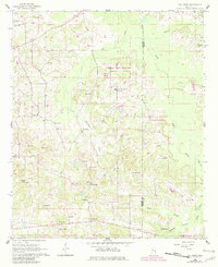
1962 Map of Owl Creek
USGS Topo · Published 1982About this map
The Choctaw Indian Reservation dominates the center of this Mississippi landscape, documenting a significant cultural geography along the border of Neshoba and Kemper counties. Rural life in the early 1960s is centered around a network of country churches and schools, such as the Bogue Chitto Indian Sch and Long Dale Sch. The topography is defined by the winding paths of Bogue Chitto Creek and Owl Creek, which feed into numerous smaller branches like Sorghum Branch and Cow Creek. Small settlements and family landmarks such as Forestdale, Bond, and Crossroads are connected by a web of local roads and unimproved trails. Notable points of interest for local history include the Sandtown Lookout Tower and a high density of small burial grounds, including Roundtree Cem and the Long Cem, which help locate early family homesteads in this wooded terrain.
Find a feature on this map
39 named features on this map. Tap any name to fly to it.
Don’t see what you’re looking for? This feature index may not catch every label — zoom into the map to look around manually.
Map Details
Editions of this 1962 Owl Creek Map
2 editions found
Other maps of this area

1953 · Meridian
USGS Topo · 1:250,000

1957 · Meridian
USGS Topo · 1:250,000

1962 · House
USGS Topo · 1:24,000

1962 · Lynville
USGS Topo · 1:24,000

1962 · Vernon
USGS Topo · 1:24,000

1962 · Owl Creek
USGS Topo · 1:24,000

1962 · Preston
USGS Topo · 1:24,000

1962 · Moscow
USGS Topo · 1:24,000

1965 · Meridian
USGS Topo · 1:250,000
1972 · Noxapater
USGS Topo · 1:24,000