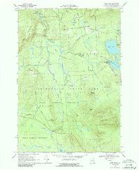
1968 Map of Owls Head
USGS Topo · Published 1988About this map
Owls Head stands as a focal point in this 1960s landscape, where the northern edge of the Adirondack State Park meets the pastoral and timbered highlands of Franklin County. The area is defined by its deep connectivity to water and rail, centered on the community of Mountain View and the nearby Mountain View Lake. Rural life in the late 1960s is evidenced by scattered landmarks like St Josephs Ch and the remote Hoose Cem near Duane. The Salmon River meanders through the northern reaches, carving notable features such as The Bend and the narrow Needles Eye, while the southern portion transitions into the dense State Forest Preserve. Small clusters of activity like Porcaville and Goldsmith highlight the persistence of small mountain settlements within the park boundary, linked by secondary routes like Titusville Road and Ayers Road.
Find a feature on this map
58 named features on this map. Tap any name to fly to it.
Don’t see what you’re looking for? This feature index may not catch every label — zoom into the map to look around manually.
Map Details
Editions of this 1968 Owls Head Map
3 editions found
Other maps of this area

1906 · Loon Lake
USGS Topo · 1:62,500

1908 · Loon Lake
USGS Topo · 1:62,500

1915 · Chateaugay
USGS Topo · 1:62,500

1915 · Malone
USGS Topo · 1:62,500

1917 · Malone
USGS Topo · 1:62,500

1921 · Santa Clara
USGS Topo · 1:62,500

1923 · Santa Clara
USGS Topo · 1:62,500

1943 · Chateaugay
USGS Topo · 1:62,500

1948 · Ogdensburg
USGS Topo · 1:250,000

1951 · Ogdensburg
USGS Topo · 1:250,000