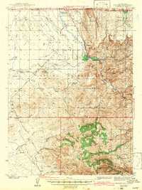
1942 Map of Owyhee
USGS Topo · Published 1942About this map
The Duck Valley Indian Reservation dominates the northern landscape of this survey, straddling the high desert borderlands between Nevada and Idaho. The Owyhee River and its South Fork provide the vital water source for the region, managed through infrastructure like the China Dam and the Lateral Canal. Small settlements such as Owyhee and Number One Settlement serve as the primary hubs of activity, while the southern portion of the map transitions into the steep, timbered reaches of the Humboldt National Forest.
Find a feature on this map
51 named features on this map. Tap any name to fly to it.
Don’t see what you’re looking for? This feature index may not catch every label — zoom into the map to look around manually.
Map Details
Editions of this 1942 Owyhee Map
3 editions found
Other maps of this area

1936 · Mountain City
USGS Topo · 1:62,500

1939 · Owyhee
USGS Topo · 1:62,500

1940 · Mountain City
USGS Topo · 1:62,500

1942 · Owyhee
USGS Topo · 1:62,500

1955 · McDermitt
USGS Topo · 1:250,000

1955 · Jordan Valley
USGS Topo · 1:250,000

1955 · Twin Falls
USGS Topo · 1:250,000

1955 · Wells
USGS Topo · 1:250,000

1956 · Bull Run
USGS Topo · 1:62,500

1956 · Wild Horse
USGS Topo · 1:62,500