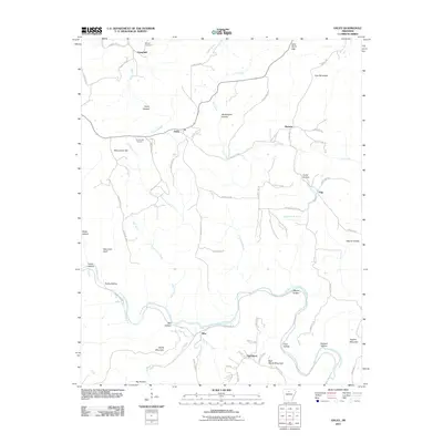
2011 Map of Oxley
USGS Topo · Published 2011About this map
The Middle Fork Little Red River meanders through the southern half of this landscape, carving out a network of steep hollows and ridges such as Styles Mountain and Half Moon Mountain. In the early 21st century, small communities like Elba, Oxley, and Harness remain connected by a web of county roads that follow the natural drainage patterns of Hurricane Creek and Tick Creek. This area is marked by numerous family-named landmarks and historical sites, including the Mabrey Cemetery near Campbell and the Kuykendall Cemetery north of McCutchen Hill. The terrain transition is sharp at Salt Cave Bluff, while the higher elevations of Alco Mountain define the northeastern corner. The presence of numerous named drainages like Tom Moss Branch and Linn Creek illustrates a landscape deeply shaped by its watercourses.
Find a feature on this map
72 named features on this map. Tap any name to fly to it.
Don’t see what you’re looking for? This feature index may not catch every label — zoom into the map to look around manually.
Map Details
Editions of this 2011 Oxley Map
This is the sole edition of this map. No revisions or reprints were ever made.
Other maps of this area

1892 · Marshall
USGS Topo · 1:125,000

1892 · Mountain View
USGS Topo · 1:125,000

1894 · Mountain View
USGS Topo · 1:125,000

1894 · Marshall
USGS Topo · 1:125,000

1901 · Marshall
USGS Topo · 1:125,000

1956 · Russellville
USGS Topo · 1:250,000
1963 · Harriet
USGS Topo · 1:24,000

1963 · Leslie
USGS Topo · 1:24,000

1964 · Russellville
USGS Topo · 1:250,000
1965 · Botkinburg
USGS Topo · 1:24,000