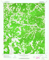
1963 Map of Harriet
USGS Topo · Published 1964About this map
Morning Star and Harriet anchor this early 1960s survey of the Ozark hills in Searcy County. The landscape is defined by deep drainage patterns where names like Big Creek, Bear Creek, and Rock Creek carve through the limestone terrain. Human presence is deeply rooted in these hollows, marked by a high density of rural religious and family landmarks. Small community centers such as Lone Pine and Baker appear alongside numerous country houses of worship, including Martin Box Chapel and Barren Hollow Ch. The mapping of fine red dashed lines indicates selected fence and field boundaries, providing a rare look at the mid-century agricultural footprint. Notable topographic features such as the Devils Backbone and Stephenson Mountain overlook a network of cemeteries—including Cypert Cem, Red Hill Cem, and East Lawn Cem—that serve as vital records for regional genealogists and local historians.
Find a feature on this map
50 named features on this map. Tap any name to fly to it.
Don’t see what you’re looking for? This feature index may not catch every label — zoom into the map to look around manually.
Map Details
Editions of this 1963 Harriet Map
2 editions found
Other maps of this area

1890 · Mountain Home
USGS Topo · 1:125,000

1891 · Mountain Home
USGS Topo · 1:125,000

1892 · Marshall
USGS Topo · 1:125,000

1892 · Mountain View
USGS Topo · 1:125,000

1893 · Yellville
USGS Topo · 1:125,000

1894 · Mountain View
USGS Topo · 1:125,000

1894 · Mountain Home
USGS Topo · 1:125,000

1894 · Marshall
USGS Topo · 1:125,000

1901 · Marshall
USGS Topo · 1:125,000

1903 · Yellville
USGS Topo · 1:125,000