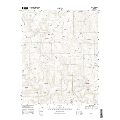
2017 Map of Oxley
USGS Topo · Published 2017About this map
The Middle Fork Little Red River carves through the Ozark landscape of Searcy, Van Buren, and Stone counties, anchoring a network of small settlements and hollows. In this part of Arkansas, the terrain is defined by prominent elevations such as Lee Mtn, Blue Mtn, and Styles Mtn, which separate numerous seasonal drainage paths like Hurricane Cr and Tick Cr. The settlement patterns follow the winding roads and narrow valleys, with Elba, Oxley, and Dennard serving as local hubs. Traces of earlier transit and family history are evident in the Old Stagecoach route and sites like Mabrey Cem and Kuykendall Cem. The map reveals a deeply dissected plateau where the community names — such as Harness and Flag — and topographical features like Salt Cave Bluff reflect the region's rural character and geological complexity.
Find a feature on this map
102 named features on this map. Tap any name to fly to it.
Don’t see what you’re looking for? This feature index may not catch every label — zoom into the map to look around manually.
Map Details
Editions of this 2017 Oxley Map
This is the sole edition of this map. No revisions or reprints were ever made.
Other maps of this area

1892 · Marshall
USGS Topo · 1:125,000

1892 · Mountain View
USGS Topo · 1:125,000

1894 · Mountain View
USGS Topo · 1:125,000

1894 · Marshall
USGS Topo · 1:125,000

1901 · Marshall
USGS Topo · 1:125,000

1956 · Russellville
USGS Topo · 1:250,000
1963 · Harriet
USGS Topo · 1:24,000

1963 · Leslie
USGS Topo · 1:24,000

1964 · Russellville
USGS Topo · 1:250,000
1965 · Botkinburg
USGS Topo · 1:24,000