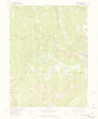
1977 Map of Oyster Lake
USGS Topo · Published 1978About this map
Flat Tops dominate this high-altitude landscape in the White River National Forest, where the plateau terrain drops sharply into deep drainage basins. Published in the late 1970s, the map reveals a network of pack trails that provide the only access through the Flat Tops Wilderness, crossing the border between Rio Blanco and Garfield counties. This environment is defined by its water system, with Oyster Lake and Papoose Lake serving as central landmarks. Significant peaks like Camel Peak and Rat Mountain rise above the basin floors, while numerous smaller bodies of water such as Mackerel Lakes and Slide Lake are scattered across the high country. The cartography details the complex relationship between the flat-topped ridges and the steep-walled valleys carved by Papoose Creek, Ute Creek, and the various branches of Marvine Creek.
Find a feature on this map
29 named features on this map. Tap any name to fly to it.
Don’t see what you’re looking for? This feature index may not catch every label — zoom into the map to look around manually.
Map Details
Editions of this 1977 Oyster Lake Map
4 editions found
Other maps of this area

1906 · Grand Hogback
USGS Topo · 1:125,000

1910 · Danforth Hills
USGS Topo · 1:125,000

1910 · Grand Hogback
USGS Topo · 1:125,000

1927 · Glenwood Springs
USGS Topo · 1:125,000

1930 · Glenwood Springs
USGS Topo · 1:125,000

1954 · Craig
USGS Topo · 1:250,000

1957 · Craig
USGS Topo · 1:250,000

1957 · Leadville
USGS Topo · 1:250,000

1958 · Craig
USGS Topo · 1:250,000

1959 · Leadville
USGS Topo · 1:250,000