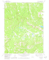
1977 Map of Oyster Lake
USGS Topo · Published 1982About this map
White River National Forest defines this high-elevation landscape in northwest Colorado, where the transition between Rio Blanco and Garfield counties is marked by an indefinite boundary. The terrain is characterized by the massive uplift of The Flat Tops, a volcanic plateau featuring steep escarpments and alpine basins like Papoose Basin. A complex drainage network feeds numerous high-country lakes, including the central Oyster Lake, the tiered Marvine Lakes, and the isolated Mistake Lakes. This 1970s survey captures the area's transition into more formal protection, shown by the Wilderness Boundary for the Flat Tops Wilderness. The reliance on a Pack Trail network, with routes following West Marvine Creek and Lost Solar Creek, underscores the lack of road infrastructure and the continued use of traditional backcountry transport in this part of the Rockies.
Find a feature on this map
29 named features on this map. Tap any name to fly to it.
Don’t see what you’re looking for? This feature index may not catch every label — zoom into the map to look around manually.
Map Details
Editions of this 1977 Oyster Lake Map
4 editions found
Other maps of this area

1906 · Grand Hogback
USGS Topo · 1:125,000

1910 · Danforth Hills
USGS Topo · 1:125,000

1910 · Grand Hogback
USGS Topo · 1:125,000

1927 · Glenwood Springs
USGS Topo · 1:125,000

1930 · Glenwood Springs
USGS Topo · 1:125,000

1954 · Craig
USGS Topo · 1:250,000

1957 · Craig
USGS Topo · 1:250,000

1957 · Leadville
USGS Topo · 1:250,000

1958 · Craig
USGS Topo · 1:250,000

1959 · Leadville
USGS Topo · 1:250,000