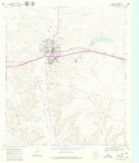
1967 Map of Ozona
USGS Topo · Published 1979About this map
Ozona serves as the focal point of this Crockett County survey, positioned at the convergence of vital West Texas draws including Johnson Draw, Gurley Draw, and Live Oak Draw. This 1967 landscape is defined by the extraction and transportation of natural resources, visible through the extensive Ozona Gas and Field and a complex network of pipelines that traverse the terrain. The community's mid-century infrastructure is remarkably detailed, showing the Ozona Airfield north of town and social hubs such as the Drive-in Theater, Ozona Country Club, and the Fairground. Local genealogists will find the location of the Cedar Hill Cem and the County Hospital particularly useful for tracing family history. The map also documents the evolving transportation routes of the era, including the path of Highway 290 and Highway 163 before major modern bypasses altered the local traffic flow.
Find a feature on this map
21 named features on this map. Tap any name to fly to it.
Don’t see what you’re looking for? This feature index may not catch every label — zoom into the map to look around manually.
Map Details
Editions of this 1967 Ozona Map
2 editions found
Other maps of this area

1954 · Sonora
USGS Topo · 1:250,000

1958 · Sonora
USGS Topo · 1:250,000

1967 · Ozona
USGS Topo · 1:24,000

1967 · Baggett Ranch
USGS Topo · 1:24,000

1967 · Double Mill Draw SE
USGS Topo · 1:24,000

1967 · Ozona SE
USGS Topo · 1:24,000

1967 · Indio Hill
USGS Topo · 1:24,000

1967 · Hunt Ranch
USGS Topo · 1:24,000

1967 · Crockett Heights
USGS Topo · 1:24,000
1967 · Schneeman Draw SE
USGS Topo · 1:24,000