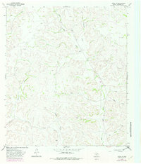
1967 Map of Ozona SE
USGS Topo · Published 1982About this map
The West Texas ranchlands of Crockett County are defined by a complex drainage system shown in this mid-century topographical record. Named family holdings like Read Ranch and Perner Ranch anchor the landscape, which is incised by numerous waterways such as Taylor Box Draw, Baggett Draw, and Chapman Draw. The terrain shifts from open plateaus to carved features like Shaggy Canyon and Plum Canyon, illustrating the importance of water management and land use in this arid region. Industrial activity is indicated by several Gas Well sites and Gravel Pit locations, while a remote Landing Strip and the small settlement of Henn suggest the infrastructure needed to support these isolated ranching operations. The detailed mapping of these family-named landmarks provides essential geographic context for researchers of Texas ranching history.
Find a feature on this map
14 named features on this map. Tap any name to fly to it.
Don’t see what you’re looking for? This feature index may not catch every label — zoom into the map to look around manually.
Map Details
Editions of this 1967 Ozona SE Map
2 editions found
Other maps of this area

1954 · Sonora
USGS Topo · 1:250,000

1958 · Sonora
USGS Topo · 1:250,000

1967 · Nolen Draw
USGS Topo · 1:24,000

1967 · Ozona
USGS Topo · 1:24,000

1967 · Baggett Ranch
USGS Topo · 1:24,000

1967 · Ozona SE
USGS Topo · 1:24,000

1967 · Shafter Draw
USGS Topo · 1:24,000

1967 · Crockett Heights
USGS Topo · 1:24,000
1967 · Hospital Ranch
USGS Topo · 1:24,000

1969 · Wild Horse Canyon
USGS Topo · 1:24,000