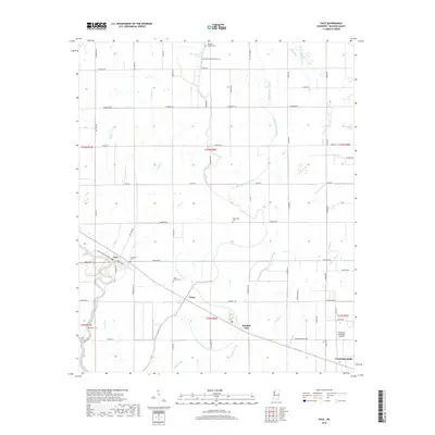
2018 Map of Pace
USGS Topo · Published 2018About this map
Pace and the rural outskirts of Cleveland anchor this Bolivar County landscape, where the agricultural grid is deeply etched by a complex network of waterways. The sluggish meandering of Bogue Phalia and the branching paths of Big Bradford Bayou and W Bogue Hasty define the drainage of this Delta region. This survey highlights the distribution of small community landmarks, particularly a series of cemeteries including Bellamy Chapel Cem and Saint Peter Cem, which often serve as the primary markers of earlier settlement patterns. The map also traces the infrastructure of the era, from the Cleveland Municipal Airport in the southeast to the railroad line passing through the heart of Victor. This document offers an essential look at the land's transition from open brakes like Merigold Brake to a structured landscape of section lines and rural roadways.
Find a feature on this map
76 named features on this map. Tap any name to fly to it.
Don’t see what you’re looking for? This feature index may not catch every label — zoom into the map to look around manually.
Map Details
Editions of this 2018 Pace Map
This is the sole edition of this map. No revisions or reprints were ever made.
Other maps of this area

1931 · Drew
USGS Topo · 1:48,000

1934 · Cleveland
USGS Topo · 1:62,500

1935 · Mound Bayou
USGS Topo · 1:62,500

1939 · Pace
USGS Topo · 1:62,500

1939 · Choctaw
USGS Topo · 1:62,500

1940 · Cleveland
USGS Topo · 1:62,500

1953 · Greenwood
USGS Topo · 1:250,000

1956 · Greenwood
USGS Topo · 1:250,000
1966 · Merigold
USGS Topo · 1:24,000

1966 · Cleveland
USGS Topo · 1:24,000