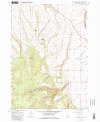
1965 Map of Packsaddle Lake
USGS Topo · Published 1980About this map
Big Hole Mountains dominate this mid-1960s landscape, where the high-altitude terrain of the Targhee National Forest meets the agricultural expanse of the Teton Basin. The map captures a transition between the wild peaks of Grandview Point and the managed lands of the University of Idaho Agricultural Experiment Station near the Teton River. This period shows a rugged interior accessed primarily by Jeep Trails, leading to landmarks like Packsaddle Lake and uniquely named summits such as Susies Nipple and Campbells Hump. The water network is particularly detailed, tracing the courses of Milk Creek, Packsaddle Creek, and various forks and hollows that define the watershed. Evidence of local infrastructure is sparse but notable, including a remote Landing Strip and grain Storage Bins at the basin's edge, reflecting the region's dual identity as a timber and ranching frontier.
Find a feature on this map
29 named features on this map. Tap any name to fly to it.
Don’t see what you’re looking for? This feature index may not catch every label — zoom into the map to look around manually.
Map Details
Editions of this 1965 Packsaddle Lake Map
2 editions found
Other maps of this area

1943 · Driggs
USGS Topo · 1:62,500

1943 · Garns Mtn
USGS Topo · 1:62,500

1946 · Driggs
USGS Topo · 1:62,500

1946 · Garns Mtn
USGS Topo · 1:62,500

1955 · Driggs
USGS Topo · 1:250,000

1958 · Driggs
USGS Topo · 1:250,000

1962 · Driggs
USGS Topo · 1:250,000

1965 · Lamont
USGS Topo · 1:24,000

1965 · Packsaddle Lake
USGS Topo · 1:24,000
1965 · Linderman Dam
USGS Topo · 1:24,000