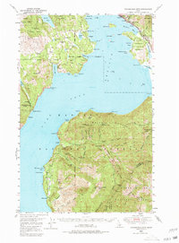
1949 Map of Packsaddle Mtn
USGS Topo · Published 1980About this map
Lake Pend Oreille dominates this mid-century landscape, surrounded by the steep peaks of the Kaniksu National Forest. The northern shore is marked by the industrial and transport corridor of the Northern Pacific railroad, connecting the settlements of Hope and East Hope. This area shows a transition from lakeside habitation at Glengary and Talache to the extraction-heavy interior where numerous mining operations are noted.
Find a feature on this map
96 named features on this map. Tap any name to fly to it.
Don’t see what you’re looking for? This feature index may not catch every label — zoom into the map to look around manually.
Map Details
Editions of this 1949 Packsaddle Mtn Map
3 editions found
Other maps of this area

1901 · Sandpoint
USGS Topo · 1:125,000

1903 · Rathdrum
USGS Topo · 1:125,000

1909 · Cataldo
USGS Topo · 1:125,000

1911 · Cataldo
USGS Topo · 1:125,000

1911 · Priest Lake
USGS Topo · 1:250,000

1911 · Sandpoint
USGS Topo · 1:125,000

1913 · Priest Lake
USGS Topo · 1:250,000

1949 · Packsaddle Mtn
USGS Topo · 1:62,500

1951 · Packsaddle Mtn
USGS Topo · 1:62,500

1951 · Clark Fork
USGS Topo · 1:62,500