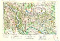
1949 Map of Paducah
USGS Topo · Published 1971About this map
The Ohio River and Mississippi River converge at Cairo, forming the geographic heart of this mid-century survey where Illinois, Kentucky, and Missouri meet. This regional hub showcases a landscape defined by massive water management and conservation projects, including the newly formed Lake Barkley and Kentucky Lake on the Cumberland River and Tennessee River. The industrial and coal-mining character of southern Illinois is evident in the cluster of towns around Carbondale, Herrin, and Marion, supported by a dense network of the Illinois Central RR and Louisville & Nashville RR. Public lands dominate the central corridor, from the Shawnee National Forest to the Crab Orchard National Wildlife Refuge. The map captures a transitional era of transportation, where river ferries and islands like Powers Island and Kaskaskia Island coexist with an expanding system of U.S. Highways and state parks.
Find a feature on this map
217 named features on this map. Tap any name to fly to it.
Don’t see what you’re looking for? This feature index may not catch every label — zoom into the map to look around manually.
Map Details
Editions of this 1949 Paducah Map
2 editions found

Other maps of this area

1903 · New Harmony
USGS Topo · 1:62,500

1903 · Patoka
USGS Topo · 1:125,000

1905 · Eldorado
USGS Topo · 1:62,500

1905 · New Haven
USGS Topo · 1:62,500

1906 · New Haven
USGS Topo · 1:62,500

1906 · Eldorado
USGS Topo · 1:62,500

1907 · Morganfield
USGS Topo · 1:62,500

1907 · Weingarten
USGS Topo · 1:62,500
1908 · Galatia
USGS Topo · 1:62,500
1908 · Princeton
USGS Topo · 1:62,500