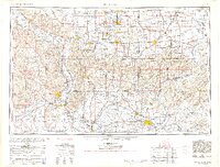
1954 Map of Paducah
USGS Topo · Published 1954About this map
Mississippi River and Ohio River confluences dominate this mid-century portrait of the tri-state region where Illinois, Kentucky, and Missouri meet. The landscape is defined by its massive water systems, including the Tennessee River, Cumberland River, and Wabash River, which historically shaped the development of regional hubs like Paducah and Cairo. In southern Illinois, the Shawnee National Forest and the Crab Orchard National Wildlife Refuge represent significant early conservation efforts, while the presence of Strip mines near Murphysboro and Marion highlights the importance of the coal industry to the local economy.
Find a feature on this map
95 named features on this map. Tap any name to fly to it.
Don’t see what you’re looking for? This feature index may not catch every label — zoom into the map to look around manually.
Map Details
Editions of this 1954 Paducah Map
2 editions found

Other maps of this area

1903 · New Harmony
USGS Topo · 1:62,500

1903 · Patoka
USGS Topo · 1:125,000

1905 · Eldorado
USGS Topo · 1:62,500

1905 · New Haven
USGS Topo · 1:62,500

1906 · New Haven
USGS Topo · 1:62,500

1906 · Eldorado
USGS Topo · 1:62,500

1907 · Morganfield
USGS Topo · 1:62,500

1907 · Weingarten
USGS Topo · 1:62,500
1908 · Galatia
USGS Topo · 1:62,500
1908 · Princeton
USGS Topo · 1:62,500