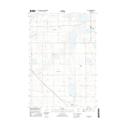
2016 Map of Page Lake
USGS Topo · Published 2016About this map
Hancock anchors the southern edge of this West Central Minnesota landscape, situated just south of the large basin of Page Lake. This 2016 survey illustrates a region defined by its glacial heritage, where numerous water bodies like Lake Cyrus, Lake Charlotte, and Round Lake are scattered across the prairie. The presence of Lakeside Cem near the shores of Page Lake and the localized Brown's Private Airport to the northeast provide specific landmarks for family historians and local researchers. The western portion of the quadrangle is bisected by the Pomme de Terre River, while the Prairie Pothole Trail cuts through the center, marking the transition between agricultural fields and the wetlands of the Solvie Slough area. The road network, including State HWY 329 and Old HWY 9, follows the established section lines of the Public Land Survey System, reflecting the organized settlement patterns of Stevens County.
Find a feature on this map
43 named features on this map. Tap any name to fly to it.
Don’t see what you’re looking for? This feature index may not catch every label — zoom into the map to look around manually.
Map Details
Editions of this 2016 Page Lake Map
This is the sole edition of this map. No revisions or reprints were ever made.
Other maps of this area

1912 · Morris
USGS Topo · 1:62,500

1953 · Saint Cloud
USGS Topo · 1:250,000

1957 · Saint Cloud
USGS Topo · 1:250,000

1958 · Saint Cloud
USGS Topo · 1:250,000

1968 · Cyrus
USGS Topo · 1:24,000

1968 · Hancock
USGS Topo · 1:24,000

1968 · Starbuck NW
USGS Topo · 1:24,000
1968 · Clontarf North
USGS Topo · 1:24,000
1968 · Hancock NW
USGS Topo · 1:24,000
1973 · Morris
USGS Topo · 1:24,000