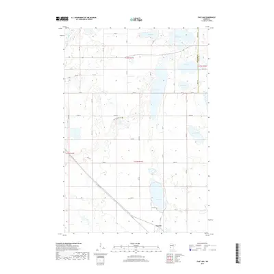
2019 Map of Page Lake
USGS Topo · Published 2019About this map
Hancock anchors the southern portion of this Stevens County landscape, situated along the diagonal path of Old Hwy 9. The area is defined by a dense concentration of glacial lakes and wetlands, typical of the Minnesota prairie pothole region. Large water bodies including Long Lake, Lake Cyrus, and the map's namesake Page Lake dominate the eastern half of the sheet, while the Pomme de Terre River cuts through the northwest corner. This 2019 survey documents the modern intersection of agricultural grid roads like Co Hwy 10 and 450th Ave with preserved natural spaces. The Prairie Pothole Trail winds through the central sections, highlighting the local conservation efforts, while the Lakeside Cem near the north shore of Page Lake provides a specific point of interest for those researching local family history.
Find a feature on this map
44 named features on this map. Tap any name to fly to it.
Don’t see what you’re looking for? This feature index may not catch every label — zoom into the map to look around manually.
Map Details
Editions of this 2019 Page Lake Map
This is the sole edition of this map. No revisions or reprints were ever made.
Other maps of this area

1912 · Morris
USGS Topo · 1:62,500

1953 · Saint Cloud
USGS Topo · 1:250,000

1957 · Saint Cloud
USGS Topo · 1:250,000

1958 · Saint Cloud
USGS Topo · 1:250,000

1968 · Cyrus
USGS Topo · 1:24,000

1968 · Hancock
USGS Topo · 1:24,000

1968 · Starbuck NW
USGS Topo · 1:24,000
1968 · Clontarf North
USGS Topo · 1:24,000
1968 · Hancock NW
USGS Topo · 1:24,000
1973 · Morris
USGS Topo · 1:24,000