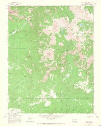
1964 Map of Pagosa Peak
USGS Topo · Published 1968About this map
Pagosa Peak dominates this high-altitude landscape within the San Juan National Forest as it appeared in the mid-1960s. The terrain is defined by a dense network of mountain hydrology, from the Piedra River and its cascading Piedra Falls to high alpine basins containing Upper Fourmile Lake and Turkey Creek Lake. Human presence is concentrated around remote outposts like Minor Notch Ranch and Cade Ranch, reflecting the area's legacy of high-country ranching and resource management. The map documents early irrigation efforts through features like the East Fork Piedra Ditch and Dutton Ditch, which divert water across complex ridges. Travel through these summits relied on established routes such as the Fourmile Stock Trail and the Rainbow Trail (Pack), tracing the same paths used by generations of livestock drivers and forest rangers before the era of modern road development.
Find a feature on this map
50 named features on this map. Tap any name to fly to it.
Don’t see what you’re looking for? This feature index may not catch every label — zoom into the map to look around manually.
Map Details
Editions of this 1964 Pagosa Peak Map
3 editions found
Other maps of this area

1905 · San Cristobal
USGS Topo · 1:125,000

1907 · San Cristobal
USGS Topo · 1:125,000

1913 · Summitville
USGS Topo · 1:125,000

1914 · Creede
USGS Topo · 1:125,000

1915 · Summitville
USGS Topo · 1:125,000

1916 · Creede
USGS Topo · 1:125,000

1924 · Pagosa Springs
USGS Topo · 1:125,000

1927 · Pagosa Springs
USGS Topo · 1:125,000

1945 · Durango
USGS Topo · 1:250,000

1953 · Durango
USGS Topo · 1:250,000