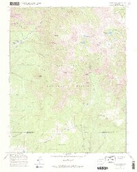
1964 Map of Pagosa Peak
USGS Topo · Published 1968About this map
Pagosa Peak dominates the high alpine terrain of the San Juan National Forest, where the transition from high ridgelines to deep river valleys defines the local topography. In the mid-1960s, this area of Mineral and Archuleta counties remained largely undeveloped, characterized by remote outposts like Minor Notch Ranch and Cade Ranch. The landscape is etched by a complex network of water management and transit routes, including the Piedra Ditch and the Fourmile Stock Trail, which underscore the region's historical reliance on seasonal grazing and high-altitude irrigation. Significant landmarks such as The Steel Bridge and Piedra Falls provide orientation points along the waterways. The presence of Windy Pass and named summits like Cade Mountain and Eagle Mountain highlights the formidable natural barriers that shaped early travel and land use in this part of the Colorado Rockies.
Find a feature on this map
50 named features on this map. Tap any name to fly to it.
Don’t see what you’re looking for? This feature index may not catch every label — zoom into the map to look around manually.
Map Details
Editions of this 1964 Pagosa Peak Map
3 editions found
Other maps of this area

1905 · San Cristobal
USGS Topo · 1:125,000

1907 · San Cristobal
USGS Topo · 1:125,000

1913 · Summitville
USGS Topo · 1:125,000

1914 · Creede
USGS Topo · 1:125,000

1915 · Summitville
USGS Topo · 1:125,000

1916 · Creede
USGS Topo · 1:125,000

1924 · Pagosa Springs
USGS Topo · 1:125,000

1927 · Pagosa Springs
USGS Topo · 1:125,000

1945 · Durango
USGS Topo · 1:250,000

1953 · Durango
USGS Topo · 1:250,000