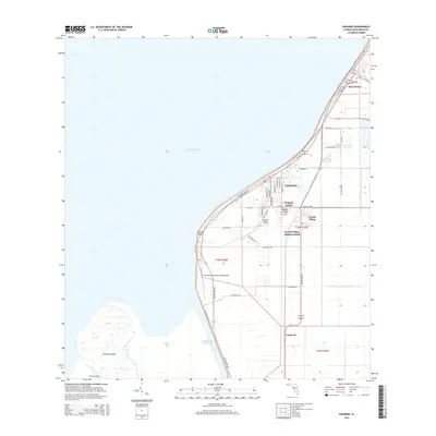
2015 Map of Pahokee
USGS Topo · Published 2015About this map
Lake Okeechobee dominates the western half of this Florida landscape, with its shoreline strictly defined by the Okeechobee Waterway and the protective levee carrying the Florida National Scenic Trail. The eastern mucklands, historically reclaimed for agriculture, are gridded by a dense network of roads such as Muck City Rd and Bay Bottom Rd, reflecting the intensive land use of the Everglades' northern edge. Settlements like Pahokee, Canal Point, and Fremd Village cluster along the lakefront, while specialized infrastructure like the Palm Beach County Glades Airport serves this productive interior. The map also captures a series of large islands within the lake's marshy periphery, including Kreamer Island, Torry Island, and Padgett Island, which remain distinct landmarks in the shallow waters of Pelican Bay.
Find a feature on this map
48 named features on this map. Tap any name to fly to it.
Don’t see what you’re looking for? This feature index may not catch every label — zoom into the map to look around manually.
Map Details
Editions of this 2015 Pahokee Map
This is the sole edition of this map. No revisions or reprints were ever made.
Other maps of this area

1956 · West Palm Beach
USGS Topo · 1:250,000

1957 · West Palm Beach
USGS Topo · 1:250,000

1958 · West Palm Beach
USGS Topo · 1:250,000

1970 · Lake Harbor
USGS Topo · 1:24,000

1970 · Belle Glade
USGS Topo · 1:24,000

1970 · Pahokee
USGS Topo · 1:24,000

1970 · Bryant
USGS Topo · 1:24,000

1970 · Sixmile Bend
USGS Topo · 1:24,000
1971 · Port Mayaca
USGS Topo · 1:24,000
1981 · West Palm Beach
USGS Topo · 1:100,000