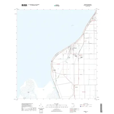
2018 Map of Pahokee
USGS Topo · Published 2018About this map
Lake Okeechobee defines the western horizon of this quadrangle, where the massive freshwater body meets the fertile muck lands of the Everglades. The city of Pahokee occupies the shoreline, anchored by a grid of streets that transition into the vast agricultural tracts characteristic of this region. The landscape is heavily managed by a network of drainage infrastructure, including the Rim Canal Rd and the Okeechobee Waterway, which were essential for transforming the wetlands into productive soil. Notable landforms within the lake and its marshes include Kreamer Island, Torry Island, and Pelican Island. The map also reveals smaller clusters of development such as Fremd Village and Cardwell, alongside the Palm Beach County Glades Airport. For those following the perimeter of the lake, the Florida National Scenic Trail winds along the levee, providing a continuous path through this unique environment.
Find a feature on this map
42 named features on this map. Tap any name to fly to it.
Don’t see what you’re looking for? This feature index may not catch every label — zoom into the map to look around manually.
Map Details
Editions of this 2018 Pahokee Map
This is the sole edition of this map. No revisions or reprints were ever made.
Other maps of this area

1956 · West Palm Beach
USGS Topo · 1:250,000

1957 · West Palm Beach
USGS Topo · 1:250,000

1958 · West Palm Beach
USGS Topo · 1:250,000

1970 · Lake Harbor
USGS Topo · 1:24,000

1970 · Belle Glade
USGS Topo · 1:24,000

1970 · Pahokee
USGS Topo · 1:24,000

1970 · Bryant
USGS Topo · 1:24,000

1970 · Sixmile Bend
USGS Topo · 1:24,000
1971 · Port Mayaca
USGS Topo · 1:24,000
1981 · West Palm Beach
USGS Topo · 1:100,000