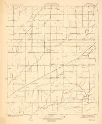
1927 Map of Paige
USGS Topo · Published 1927About this map
Paige serves as a central point in this agricultural landscape within Tulare County, defined by a rigorous grid of section lines and irrigation infrastructure. The expansion of the Atchison Topeka and Santa Fe railroad through the territory illustrates the importance of rail transit for San Joaquin Valley farmers in the mid-1920s. A network of waterways including Packwood Creek, Cameron Creek, and the Tulare Canal highlights the complex water management required to sustain local orchards and fields.
Find a feature on this map
19 named features on this map. Tap any name to fly to it.
Don’t see what you’re looking for? This feature index may not catch every label — zoom into the map to look around manually.
Map Details
Editions of this 1927 Paige Map
2 editions found
Other maps of this area

1925 · Tulare
USGS Topo · 1:31,680

1925 · Tipton
USGS Topo · 1:31,680

1926 · Goshen
USGS Topo · 1:31,680

1927 · Remnoy
USGS Topo · 1:31,680

1927 · Lake View School
USGS Topo · 1:31,680

1927 · Paige
USGS Topo · 1:31,680

1927 · Visalia
USGS Topo · 1:31,680

1927 · Tulare
USGS Topo · 1:31,680

1928 · Tipton
USGS Topo · 1:31,680

1928 · Waukena
USGS Topo · 1:31,680