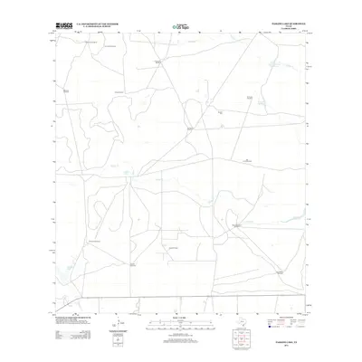
2013 Map of Paisano Lake
USGS Topo · Published 2013About this map
Windmills and waterholes define this south Texas landscape, where life and industry depend on scattered water sources across Kleberg County. The map shows a network of named ranching sites including Banqueros Windmill, Lidios Windmill, and Alta la Pita Windmill, alongside natural points such as Cuatro de Julio Waterhole and El Perdido Waterhole. These features, many bearing family or Spanish names, suggest a history of cattle ranching and land management in a dry environment. The presence of the Canelo Oil Field introduces a modern industrial layer to the traditional pastoral character of the area. Waterways like Radicha Cr and Salado Cr drain toward localized basins such as Canelo Lake and Paisano Lake, while the Canales Cem provides a tangible link for genealogists researching the families of this region.
Find a feature on this map
22 named features on this map. Tap any name to fly to it.
Don’t see what you’re looking for? This feature index may not catch every label — zoom into the map to look around manually.
Map Details
Editions of this 2013 Paisano Lake Map
This is the sole edition of this map. No revisions or reprints were ever made.
Other maps of this area

1921 · Falfurrias
USGS Topo · 1:125,000

1928 · Sarita
USGS Topo · 1:125,000

1950 · Corpus Christi
USGS Topo · 1:250,000

1954 · Sarita
USGS Topo · 1:62,500

1954 · Riviera
USGS Topo · 1:62,500

1956 · Corpus Christi
USGS Topo · 1:250,000

1956 · Laredo
USGS Topo · 1:250,000

1960 · Corpus Christi
USGS Topo · 1:250,000

1963 · Flowella
USGS Topo · 1:24,000
1963 · Premont East
USGS Topo · 1:24,000