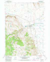
1966 Map of Paisley
USGS Topo · Published 1980About this map
The Chewaucan River emerges from the steep, timbered slopes of the Fremont National Forest to water the high desert basin of Lake County. This mid-1960s survey, updated in 1980, centers on the ranching community of Paisley, where the river’s flow is diverted into an extensive network of irrigation works including the Red House Canal, Outside Canal, and Brattain Canal. These systems support the sprawling ZX Ranch and the fertile Upper Chewaucan Marsh to the east.
Find a feature on this map
37 named features on this map. Tap any name to fly to it.
Don’t see what you’re looking for? This feature index may not catch every label — zoom into the map to look around manually.
Map Details
Editions of this 1966 Paisley Map
3 editions found
Other maps of this area

1955 · Klamath Falls
USGS Topo · 1:250,000

1958 · Klamath Falls
USGS Topo · 1:250,000

1966 · Morgan Butte
USGS Topo · 1:24,000

1966 · Tucker Hill
USGS Topo · 1:24,000

1966 · Slide Mtn
USGS Topo · 1:24,000

1966 · Coglan Buttes
USGS Topo · 1:24,000

1966 · Coffeepot Creek
USGS Topo · 1:24,000

1966 · Paisley
USGS Topo · 1:24,000

1974 · Lake Abert
USGS Topo · 1:100,000

1985 · Sharp Top
USGS Topo · 1:24,000