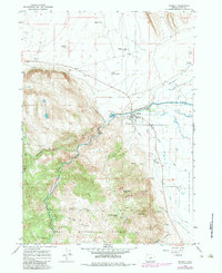
1966 Map of Paisley
USGS Topo · Published 1984About this map
Paisley serves as the focal point of this high-desert landscape, where the Chewaucan River emerges from the steep terrain of the Fremont National Forest to meet the expansive lowlands. The area's agricultural and ranching history is anchored by the ZX Ranch and its ZX Ranch Red House, alongside a complex network of water management features including the Red House Ditch, Outside Canal, and Jones Canal. These irrigation works suggest a carefully managed transition from the river to the Upper Chewaucan Marsh.
Find a feature on this map
44 named features on this map. Tap any name to fly to it.
Don’t see what you’re looking for? This feature index may not catch every label — zoom into the map to look around manually.
Map Details
Editions of this 1966 Paisley Map
3 editions found
Other maps of this area

1955 · Klamath Falls
USGS Topo · 1:250,000

1958 · Klamath Falls
USGS Topo · 1:250,000

1966 · Morgan Butte
USGS Topo · 1:24,000

1966 · Tucker Hill
USGS Topo · 1:24,000

1966 · Slide Mtn
USGS Topo · 1:24,000

1966 · Coglan Buttes
USGS Topo · 1:24,000

1966 · Coffeepot Creek
USGS Topo · 1:24,000

1966 · Paisley
USGS Topo · 1:24,000

1974 · Lake Abert
USGS Topo · 1:100,000

1985 · Sharp Top
USGS Topo · 1:24,000