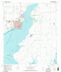
1995 Map of Palacios
USGS Topo · Published 1995About this map
Tres Palacios Bay dominates this coastal landscape, where the town of Palacios sits as a hub for maritime and industrial activity in the mid-1990s. The shoreline is defined by numerous piers and public spaces like Foley Reserve Park and Palacios South Base Park, alongside critical infrastructure including the Palacios Municipal Airport and a complex Sewage Disposal system. The grid of the city, featuring Main St and Henderson St, reflects an established community with its own Hospital and school system.
Find a feature on this map
37 named features on this map. Tap any name to fly to it.
Don’t see what you’re looking for? This feature index may not catch every label — zoom into the map to look around manually.
Map Details
Editions of this 1995 Palacios Map
This is the sole edition of this map. No revisions or reprints were ever made.
Other maps of this area

1952 · Palacios SE
USGS Topo · 1:24,000

1952 · Palacios Point
USGS Topo · 1:24,000

1952 · Blessing SE
USGS Topo · 1:24,000

1952 · Palacios
USGS Topo · 1:24,000

1952 · Turtle Bay
USGS Topo · 1:24,000

1952 · Francitas
USGS Topo · 1:24,000

1952 · Blessing
USGS Topo · 1:24,000

1952 · Palacios NE
USGS Topo · 1:24,000

1953 · Beeville
USGS Topo · 1:250,000

1956 · Beeville
USGS Topo · 1:250,000