
1952 Map of Blessing SE
USGS Topo · Published 1953About this map
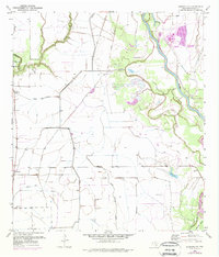
The low-lying coastal prairies of Matagorda County are defined here by a complex network of wetlands and hydraulic engineering. The Colorado River meanders through the eastern portion of the map, creating large landforms like Selkirk Island and Wild Cow Island, while the West Branch Colorado River further bifurcates the terrain. Extensive levee systems and an abandoned canal indicate a landscape heavily modified for water management and flood control.
Find a feature on this map
19 named features on this map. Tap any name to fly to it.
Don’t see what you’re looking for? This feature index may not catch every label — zoom into the map to look around manually.
Map Details
Editions of this 1952 Blessing SE Map
2 editions found
Other maps of this area

1951 · Bay City
USGS Topo · 1:250,000

1952 · Matagorda
USGS Topo · 1:24,000

1952 · Palacios
USGS Topo · 1:24,000

1952 · Blessing
USGS Topo · 1:24,000

1952 · Bay City
USGS Topo · 1:24,000

1952 · Markham
USGS Topo · 1:24,000

1952 · Midfield
USGS Topo · 1:24,000

1952 · Palacios NE
USGS Topo · 1:24,000

1952 · Wadsworth
USGS Topo · 1:24,000

1953 · Beeville
USGS Topo · 1:250,000