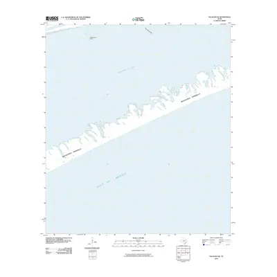
2010 Map of Palacios SE
USGS Topo · Published 2010About this map
The Matagorda Peninsula forms a narrow barrier between the open waters of the Gulf of Mexico and the protected environment of Matagorda Bay on this Matagorda County coast. This survey illustrates the intricate and fragmented shoreline of the peninsula's inner side, where a complex network of small islands and inlets meets the bay. Within these waters, navigation and ecological features are marked by Mad Island Reef and Shell Island Reef, which define the transition from the sheltered bay to the barrier landform. The map documents a pristine stretch of the Texas Gulf Coast as it appeared in the early 21st century, focusing entirely on the natural interaction of reef, bay, and peninsula without any significant inland infrastructure or settlement labels.
Find a feature on this map
5 named features on this map. Tap any name to fly to it.
Don’t see what you’re looking for? This feature index may not catch every label — zoom into the map to look around manually.
Map Details
Editions of this 2010 Palacios SE Map
This is the sole edition of this map. No revisions or reprints were ever made.
Other maps of this area

1951 · Bay City
USGS Topo · 1:250,000

1952 · Palacios SE
USGS Topo · 1:24,000

1952 · Palacios Point
USGS Topo · 1:24,000

1952 · Matagorda
USGS Topo · 1:24,000

1952 · Palacios
USGS Topo · 1:24,000
1952 · Matagorda SW
USGS Topo · 1:24,000

1952 · South of Palacios Point
USGS Topo · 1:24,000

1952 · Palacios NE
USGS Topo · 1:24,000

1953 · Beeville
USGS Topo · 1:250,000

1956 · Beeville
USGS Topo · 1:250,000