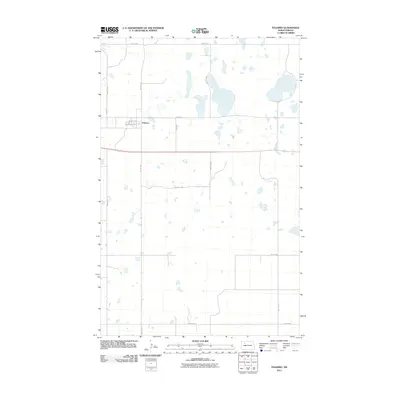
2011 Map of Palermo
USGS Topo · Published 2011About this map
Palermo stands as a central point of interest in this 2011 survey of Mountrail County, North Dakota. The settlement's grid is clearly defined by local thoroughfares such as Washington Ave and Norway Ave, sitting just north of the major east-west corridor of Old Hwy 2. The surrounding landscape is a classic example of Northern Plains prairie pothole topography, characterized by numerous unnamed small lakes and seasonal wetlands that punctuate the agricultural sections. The surveyor's grid is meticulously detailed through a network of rural roads, including 74th Ave NW and 62nd St NW, which facilitate movement between the disparate sections of this high plains environment. This map captures the region at a time when traditional section-line travel remained the primary means of navigating the area south of Palermo toward County Rd 22.
Find a feature on this map
15 named features on this map. Tap any name to fly to it.
Don’t see what you’re looking for? This feature index may not catch every label — zoom into the map to look around manually.
Map Details
Editions of this 2011 Palermo Map
This is the sole edition of this map. No revisions or reprints were ever made.
Other maps of this area

1953 · Williston
USGS Topo · 1:250,000

1957 · Williston
USGS Topo · 1:250,000

1969 · Stanley SE
USGS Topo · 1:24,000

1981 · Stanley SE
USGS Topo · 1:24,000
1981 · Palermo NE
USGS Topo · 1:24,000

1981 · Palermo
USGS Topo · 1:24,000
1981 · Shell Lake
USGS Topo · 1:24,000
1981 · Palermo NW
USGS Topo · 1:24,000
1981 · Epworth NW
USGS Topo · 1:24,000
1981 · Blaisdell
USGS Topo · 1:24,000