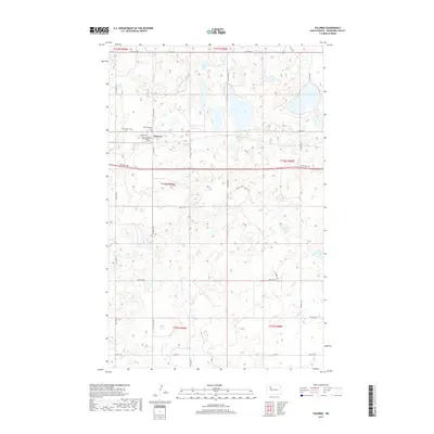
2017 Map of Palermo
USGS Topo · Published 2017About this map
The town of Palermo serves as the central hub of this Mountrail County landscape, situated where the local grid of Norway Ave, Washington Ave, and Indiana St meets the regional corridor of Old Hwy 2. The map details a high-plains geography defined by numerous small water bodies and wetlands scattered across the township sections. Local history is anchored by the presence of Rest Haven Cem and Faith Lutheran Cem, located on the western outskirts of the settlement. The infrastructure reflects a rural agricultural economy, with a network of section-line roads like 60th St NW and 74th Ave NW providing access to the open terrain. Moving south, the landscape transitions toward Co Rd 22 and the Prairie Trl, illustrating the expansive and sparsely populated character of the North Dakota prairie in the early 21st century.
Find a feature on this map
27 named features on this map. Tap any name to fly to it.
Don’t see what you’re looking for? This feature index may not catch every label — zoom into the map to look around manually.
Map Details
Editions of this 2017 Palermo Map
This is the sole edition of this map. No revisions or reprints were ever made.
Other maps of this area

1953 · Williston
USGS Topo · 1:250,000

1957 · Williston
USGS Topo · 1:250,000

1969 · Stanley SE
USGS Topo · 1:24,000

1981 · Stanley SE
USGS Topo · 1:24,000
1981 · Palermo NE
USGS Topo · 1:24,000

1981 · Palermo
USGS Topo · 1:24,000
1981 · Shell Lake
USGS Topo · 1:24,000
1981 · Palermo NW
USGS Topo · 1:24,000
1981 · Epworth NW
USGS Topo · 1:24,000
1981 · Blaisdell
USGS Topo · 1:24,000