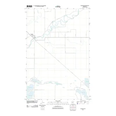
2010 Map of Palisade
USGS Topo · Published 2010About this map
The Mississippi River creates a serpentine corridor through Aitkin County, meeting the Willow River just north of the village of Palisade. This 2010 survey reflects a landscape defined by water and legacy infrastructure, where the diagonal path of the Soo Line Trl marks the former route of the Soo Line Railroad. Near the river bend, the Palisade Post Office and Berglund Park Campground serve as central points for the community. To the south, a dense cluster of glacial lakes including Jenkins Lake, Long Lake, and Fleming Lake dominates the terrain, connected by a network of local roads like Nature Ave and County Hwy 69. The map illustrates a rural Minnesota setting where modern recreational use and historical transportation routes overlap within a complex wetland environment.
Find a feature on this map
32 named features on this map. Tap any name to fly to it.
Don’t see what you’re looking for? This feature index may not catch every label — zoom into the map to look around manually.
Map Details
Editions of this 2010 Palisade Map
This is the sole edition of this map. No revisions or reprints were ever made.
Other maps of this area

1914 · Aitkin
USGS Topo · 1:62,500

1915 · Aitkin
USGS Topo · 1:62,500

1953 · Duluth
USGS Topo · 1:250,000

1958 · Duluth
USGS Topo · 1:250,000

1970 · Kimberly
USGS Topo · 1:24,000

1970 · Mc Gregor
USGS Topo · 1:24,000

1970 · Palisade
USGS Topo · 1:24,000

1970 · Sanders Lake
USGS Topo · 1:24,000

1970 · Libby
USGS Topo · 1:24,000
1970 · Minnewawa
USGS Topo · 1:24,000