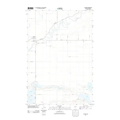
2013 Map of Palisade
USGS Topo · Published 2013About this map
The Mississippi River meanders through the heart of this Aitkin County landscape, defining the northern geography alongside its tributary, the Willow River. In the northwest, the small settlement of Palisade serves as a local hub, situated where the river makes a sharp bend. The town is marked by its Po and the Berglund Park Campground, reflecting the area's importance as a gateway to the surrounding wetlands and forests. To the south, a dense network of water bodies creates a complex lacustrine environment. Lakes such as Jenkins Lake, Wilkins Lake, and Fleming Lake are connected by a grid of rural roads like Twp Hwy 569 and Twp Hwy 625, showing a pattern of seasonal recreation and small-scale agriculture. The southern cluster also includes Rock Lake, Round Lake, and Townline Lake, illustrating the post-glacial topography typical of this region of Minnesota.
Find a feature on this map
29 named features on this map. Tap any name to fly to it.
Don’t see what you’re looking for? This feature index may not catch every label — zoom into the map to look around manually.
Map Details
Editions of this 2013 Palisade Map
This is the sole edition of this map. No revisions or reprints were ever made.
Other maps of this area

1914 · Aitkin
USGS Topo · 1:62,500

1915 · Aitkin
USGS Topo · 1:62,500

1953 · Duluth
USGS Topo · 1:250,000

1958 · Duluth
USGS Topo · 1:250,000

1970 · Kimberly
USGS Topo · 1:24,000

1970 · Mc Gregor
USGS Topo · 1:24,000

1970 · Palisade
USGS Topo · 1:24,000

1970 · Sanders Lake
USGS Topo · 1:24,000

1970 · Libby
USGS Topo · 1:24,000
1970 · Minnewawa
USGS Topo · 1:24,000