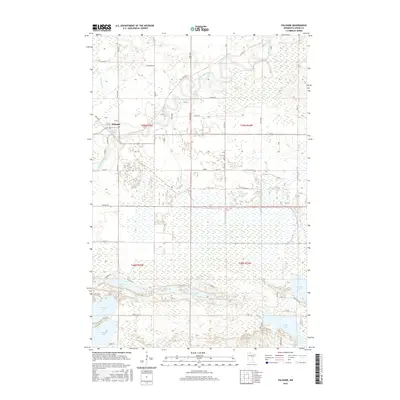
2016 Map of Palisade
USGS Topo · Published 2016About this map
Palisade sits at a significant bend where the Willow River meets the Mississippi River in northern Minnesota. This river junction defined the early settlement patterns of the region, where water transport once dictated the local economy. The surrounding landscape is characterized by extensive wetlands and a dense network of lakes across the southern half of the quadrangle, including Wilkins Lake, Fleming Lake, and Rock Lake. These water bodies are connected by a grid of rural routes such as N Willow Dr and Co Hwy 10, reflecting the transition from river-based travel to modern highway infrastructure. Further north, the St Wildlife Rd points to the preserved natural state of the Aitkin County wilderness, where the meandering path of the Mississippi remains largely untouched by heavy urban development.
Find a feature on this map
60 named features on this map. Tap any name to fly to it.
Don’t see what you’re looking for? This feature index may not catch every label — zoom into the map to look around manually.
Map Details
Editions of this 2016 Palisade Map
This is the sole edition of this map. No revisions or reprints were ever made.
Other maps of this area

1914 · Aitkin
USGS Topo · 1:62,500

1915 · Aitkin
USGS Topo · 1:62,500

1953 · Duluth
USGS Topo · 1:250,000

1958 · Duluth
USGS Topo · 1:250,000

1970 · Kimberly
USGS Topo · 1:24,000

1970 · Mc Gregor
USGS Topo · 1:24,000

1970 · Palisade
USGS Topo · 1:24,000

1970 · Sanders Lake
USGS Topo · 1:24,000

1970 · Libby
USGS Topo · 1:24,000
1970 · Minnewawa
USGS Topo · 1:24,000