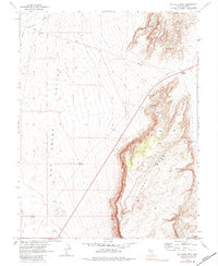
1967 Map of Palisade Mesa
USGS Topo · Published 1984About this map
Hot Creek Valley dominates the western portion of this 1967 landscape, defined by the dry course of Hot Creek and the drainage of Moores Station Wash. The terrain shifts dramatically to the east where the massive, elevated Palisade Mesa and Halligan Mesa rise above the valley floor. This desert environment is punctuated by vital water sources, including Rattlesnake Springs, Iceberg Spring, and Sandy Summit Spring, which likely served as critical stops for travelers and local ranching operations.
Find a feature on this map
15 named features on this map. Tap any name to fly to it.
Don’t see what you’re looking for? This feature index may not catch every label — zoom into the map to look around manually.
Map Details
Editions of this 1967 Palisade Mesa Map
2 editions found
Other maps of this area

1956 · Tonopah
USGS Topo · 1:250,000

1959 · Tonopah
USGS Topo · 1:250,000

1962 · Tonopah
USGS Topo · 1:250,000

1967 · Lunar Crater
USGS Topo · 1:62,500

1967 · Moores Station
USGS Topo · 1:62,500

1967 · Blue Jay Spring
USGS Topo · 1:24,000

1967 · Moores Station SE
USGS Topo · 1:24,000

1967 · Buckwheat Rim
USGS Topo · 1:24,000

1967 · Palisade Mesa
USGS Topo · 1:24,000

1967 · Lunar Crater
USGS Topo · 1:24,000