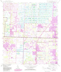
1946 Map of Palm Beach Farms
USGS Topo · Published 1983About this map
Loxahatchee Slough and the West Palm Beach Canal define the drainage and early development patterns of this Florida landscape. Originally surveyed in 1946, the map documents the transition from the agricultural roots of the Palm Beach Farms into organized suburban footprints. The expansion of the West Palm Beach vicinity is evident in the planned street grids of Royal Palm Beach and the presence of Haverhill. Large-scale infrastructure projects such as Floridas Turnpike and the Range Line Road bisect the area, illustrating the post-war transportation boom. Significant recreational and utility spaces, including Okeeheelee Park, the Palm Beach Pines State Recreation Area, and various borrow pits, show how land was repurposed as these communities grew toward Greenacres City.
Find a feature on this map
16 named features on this map. Tap any name to fly to it.
Don’t see what you’re looking for? This feature index may not catch every label — zoom into the map to look around manually.
Map Details
Editions of this 1946 Palm Beach Farms Map
3 editions found
Other maps of this area

1945 · Delta
USGS Topo · 1:24,000

1945 · Greenacres City
USGS Topo · 1:24,000

1945 · Lake Worth
USGS Topo · 1:24,000

1946 · Riviera Beach
USGS Topo · 1:24,000

1946 · Palm Beach Farms
USGS Topo · 1:24,000

1946 · Palm Beach
USGS Topo · 1:24,000

1949 · Lake Worth
USGS Topo · 1:24,000

1949 · Palm Beach Farms
USGS Topo · 1:24,000

1949 · Riviera Beach
USGS Topo · 1:24,000

1950 · Greenacres City
USGS Topo · 1:24,000