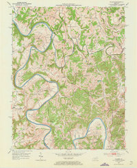
1952 Map of Palmer
USGS Topo · Published 1973About this map
The confluence of the Kentucky River and the Red River defines this landscape where Clark, Estill, and Madison Counties meet. In the early 1950s, the terrain was characterized by dramatic river meanders including Maupin Bend and Thornsburg Bend, with the Louisville and Nashville railroad providing a vital transport corridor along the northern bank. The map reveals a high density of family-named cemeteries and small rural institutions, such as Ellington Cem and the The Bend Sch, indicating a long-established community structure deeply tied to the river bottoms and ridges.
Find a feature on this map
82 named features on this map. Tap any name to fly to it.
Don’t see what you’re looking for? This feature index may not catch every label — zoom into the map to look around manually.
Map Details
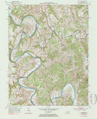
Editions of this 1952 Palmer Map
Other maps of this area

1892 · Richmond
USGS Topo · 1:125,000

1892 · Beattyville
USGS Topo · 1:125,000

1897 · Richmond
USGS Topo · 1:125,000

1950 · Levee
USGS Topo · 1:24,000

1952 · Union City
USGS Topo · 1:24,000

1952 · Palmer
USGS Topo · 1:24,000

1952 · Clay City
USGS Topo · 1:24,000

1952 · Levee
USGS Topo · 1:24,000

1952 · Winchester
USGS Topo · 1:24,000

1952 · Irvine
USGS Topo · 1:24,000