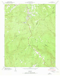
1950 Map of Palmer
USGS Topo · Published 1950About this map
The Palmer Mine and industrial operations near Palmer define the landscape of the Cumberland Plateau in this mid-century survey. Situated at the junction of Grundy, Marion, and Sequatchie counties, the area is characterized by deep coves and narrow ridges, with the N C & St L railroad extending north into the heart of the plateau's mining district. To the south, the Reel Cove Mine and a notable Conveyor Belt highlight the infrastructure required for coal extraction in the rugged terrain of Reel Cove. Genealogists will find several family-named landmarks and local burial sites, including Layne Cem and White Cem, alongside small rural hubs like Tatesville and Laager. The map also captures local community life through the Tatesville Sch and Griffith Creek Ch, providing a detailed look at these mountain settlements before further modern development altered the coalfield landscape.
Find a feature on this map
71 named features on this map. Tap any name to fly to it.
Don’t see what you’re looking for? This feature index may not catch every label — zoom into the map to look around manually.
Map Details
Editions of this 1950 Palmer Map
2 editions found
Other maps of this area

1888 · Chattanooga
USGS Topo · 1:125,000

1893 · Chattanooga
USGS Topo · 1:125,000

1895 · Sewanee
USGS Topo · 1:125,000

1936 · Palmer
USGS Topo · 1:24,000

1936 · Daus
USGS Topo · 1:24,000

1936 · Whitwell
USGS Topo · 1:24,000

1936 · Tracy City
USGS Topo · 1:24,000

1936 · Ketner Gap
USGS Topo · 1:24,000

1936 · White City
USGS Topo · 1:24,000
1936 · Savage Point
USGS Topo · 1:24,000