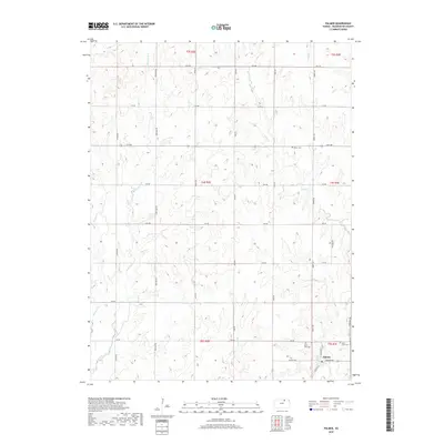
2018 Map of Palmer
USGS Topo · Published 2018About this map
Palmer serves as the primary hub of this Washington County landscape, situated at the intersection of Palmer Ave and S Ohio Ave. The town is bordered by vital agricultural lands and a network of named waterways including the E Br Parsons Cr and the winding Peats Cr. A strong sense of local heritage is evident in the cluster of sacred spaces near the settlement, such as Saint Paul Cem and Saint Louis Cem, which are central to the community's genealogy. To the north, the terrain is defined by a grid of rural routes like Heritage Rd and Indian Rd, which connect outlying points like the Reiter Cem. This 2018 survey illustrates a classic Kansas township structure, where drainage systems like Spring Cr and Ash Cr dictate the layout of the local road network and surrounding farmland.
Find a feature on this map
35 named features on this map. Tap any name to fly to it.
Don’t see what you’re looking for? This feature index may not catch every label — zoom into the map to look around manually.
Map Details
Editions of this 2018 Palmer Map
This is the sole edition of this map. No revisions or reprints were ever made.
Other maps of this area

1893 · Washington
USGS Topo · 1:125,000

1955 · Manhattan
USGS Topo · 1:250,000

1956 · Manhattan
USGS Topo · 1:250,000

1957 · Manhattan
USGS Topo · 1:250,000

1965 · Clifton
USGS Topo · 1:24,000

1965 · Brantford
USGS Topo · 1:24,000

1966 · Morrowville
USGS Topo · 1:24,000

1966 · Washington
USGS Topo · 1:24,000
1966 · Haddam
USGS Topo · 1:24,000
1968 · Linn SW
USGS Topo · 1:24,000