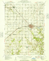
1949 Map of Pana
USGS Topo · Published 1949About this map
The city of Pana serves as the central hub of this 1940s landscape, where a dense concentration of railroads including the Baltimore and Ohio, Illinois Central, and New York Central converge. This rail infrastructure supported a thriving agricultural and industrial network across Christian, Montgomery, and Shelby counties. The map captures an era of localized rural education and faith, documented through dozens of named country schools like Durbin College Sch and Swamp Angel Sch, alongside landmarks such as Sacred Heart Ch and Town Hall.
Find a feature on this map
86 named features on this map. Tap any name to fly to it.
Don’t see what you’re looking for? This feature index may not catch every label — zoom into the map to look around manually.
Map Details
Editions of this 1949 Pana Map
2 editions found

Other maps of this area

1923 · Taylorville
USGS Topo · 1:62,500

1925 · Taylorville
USGS Topo · 1:62,500

1941 · St. Elmo
USGS Topo · 1:62,500

1942 · Shelbyville
USGS Topo · 1:62,500

1944 · Ramsey
USGS Topo · 1:62,500

1945 · St. Elmo
USGS Topo · 1:62,500

1946 · Shelbyville
USGS Topo · 1:62,500

1946 · Ramsey
USGS Topo · 1:62,500

1946 · Nokomis
USGS Topo · 1:62,500

1947 · Pana
USGS Topo · 1:62,500