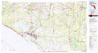
1981 Map of Panama City
USGS Topo · Published 1981About this map
St Andrew Bay and the surrounding coastline of the Florida Panhandle define this 1981 survey, capturing a region shaped by both its maritime geography and military presence. The urban core of Panama City is shown alongside growing communities like Lynn Haven, Springfield, and Callaway. To the southeast, the expansive grounds of Tyndall Air Force Base occupy the peninsula between the bay and the Gulf of Mexico, while the Naval Coastal Systems Center sits further west near Panama City Beach.
Find a feature on this map
91 named features on this map. Tap any name to fly to it.
Don’t see what you’re looking for? This feature index may not catch every label — zoom into the map to look around manually.
Map Details
Editions of this 1981 Panama City Map
2 editions found
Other maps of this area

1935 · De Funiak Springs
USGS Topo · 1:48,000

1936 · Point Washington
USGS Topo · 1:48,000

1938 · De Funiak Springs
USGS Topo · 1:62,500

1939 · Point Washington
USGS Topo · 1:62,500

1943 · Beacon Beach
USGS Topo · 1:31,680

1943 · Overstreet
USGS Topo · 1:31,680

1943 · Laguna Beach
USGS Topo · 1:31,680

1943 · Panama City
USGS Topo · 1:31,680

1943 · Crooked Island
USGS Topo · 1:31,680

1943 · Panama City Beach
USGS Topo · 1:31,680