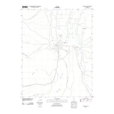
2011 Map of Panguitch
USGS Topo · Published 2011About this map
Panguitch stands as a central agricultural and civic hub along the upper Sevier River valley, defined by a meticulously planned street grid and a complex network of irrigation infrastructure. This 2011 survey illustrates the vital role of water management in the high desert, featuring the East Bench Canal, Long Canal, and East Panguitch Canal that divert water toward the town's productive outskirts. The map identifies key community landmarks such as the Garfield County Fairgrounds, the Panguitch Post Office, and the Panguitch City Cemetery, providing a clear record of the town’s modern footprint. Beyond the residential center, the landscape is marked by landforms like Roller Mill Hill and Dickinson Hill, while drainage features such as Panguitch Creek and Threemile Creek feed into the river system. The presence of the Panguitch Municipal Airport and various named washes like Butler Wash and Peterson Wash further define the intersection of natural topography and local transportation.
Find a feature on this map
39 named features on this map. Tap any name to fly to it.
Don’t see what you’re looking for? This feature index may not catch every label — zoom into the map to look around manually.
Map Details
Editions of this 2011 Panguitch Map
This is the sole edition of this map. No revisions or reprints were ever made.
Other maps of this area

1886 · Kanab
USGS Topo · 1:250,000

1953 · Cedar City
USGS Topo · 1:250,000

1958 · Cedar City
USGS Topo · 1:250,000

1958 · Panguitch Lake
USGS Topo · 1:62,500

1962 · Cedar City
USGS Topo · 1:250,000

1966 · Wilson Peak
USGS Topo · 1:24,000

1966 · Hatch
USGS Topo · 1:24,000

1966 · Panguitch NW
USGS Topo · 1:24,000

1971 · Fivemile Ridge
USGS Topo · 1:24,000
1971 · Panguitch
USGS Topo · 1:24,000