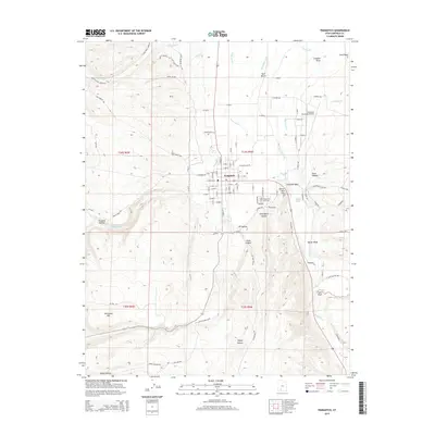
2014 Map of Panguitch
USGS Topo · Published 2014About this map
Panguitch serves as the central hub of this Garfield County landscape, where the town’s grid meets the agricultural lifeline of the Sevier River valley. The mapping detail shows a complex network of irrigation, including the E Panguitch Canal, Long Canal, and W Ditch, which support the valley floor between the elevated East Bench and the surrounding high ground. Geologists and local historians will find interest in the numerous named drainages and hollows that define the territory, such as Graveyard Hollow, Race Hollow, and Peterson Wash. To the north, the Panguitch Municipal Airport marks modern infrastructure, while the Panguitch City Cem and the rise of Roller Mill Hill provide landmarks grounded in the community's local history. The map also traces various local routes like Putt Putt Loop and Three Mile Creek Rd, illustrating the intersection of residential life and the rural Utah backcountry.
Find a feature on this map
112 named features on this map. Tap any name to fly to it.
Don’t see what you’re looking for? This feature index may not catch every label — zoom into the map to look around manually.
Map Details
Editions of this 2014 Panguitch Map
This is the sole edition of this map. No revisions or reprints were ever made.
Other maps of this area

1886 · Kanab
USGS Topo · 1:250,000

1953 · Cedar City
USGS Topo · 1:250,000

1958 · Cedar City
USGS Topo · 1:250,000

1958 · Panguitch Lake
USGS Topo · 1:62,500

1962 · Cedar City
USGS Topo · 1:250,000

1966 · Wilson Peak
USGS Topo · 1:24,000

1966 · Hatch
USGS Topo · 1:24,000

1966 · Panguitch NW
USGS Topo · 1:24,000

1971 · Fivemile Ridge
USGS Topo · 1:24,000
1971 · Panguitch
USGS Topo · 1:24,000