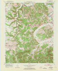
1952 Map of Panola
USGS Topo · Published 1971About this map
Kentucky River bottomlands and the dissected uplands of the Pottsville Escarpment define this region along the border of Madison and Estill counties. The landscape in the early 1950s is a dense network of ridge-top settlements and creek-hollow communities, connected by winding roads like KY 52 and the route through Wisemantown. Many small rural schools, such as Maddie Sch and Sand Hill Sch, still served these scattered neighborhoods before consolidation, while numerous family burying grounds like Hubbard and Garrison Cem mark the local genealogy of the Knobs.
Find a feature on this map
55 named features on this map. Tap any name to fly to it.
Don’t see what you’re looking for? This feature index may not catch every label — zoom into the map to look around manually.
Map Details
Editions of this 1952 Panola Map
3 editions found

Other maps of this area

1892 · Richmond
USGS Topo · 1:125,000

1892 · Beattyville
USGS Topo · 1:125,000

1897 · Richmond
USGS Topo · 1:125,000

1952 · Alcorn
USGS Topo · 1:24,000

1952 · Leighton
USGS Topo · 1:24,000

1952 · Union City
USGS Topo · 1:24,000

1952 · Palmer
USGS Topo · 1:24,000

1952 · Clay City
USGS Topo · 1:24,000

1952 · Irvine
USGS Topo · 1:24,000

1952 · Bighill
USGS Topo · 1:24,000