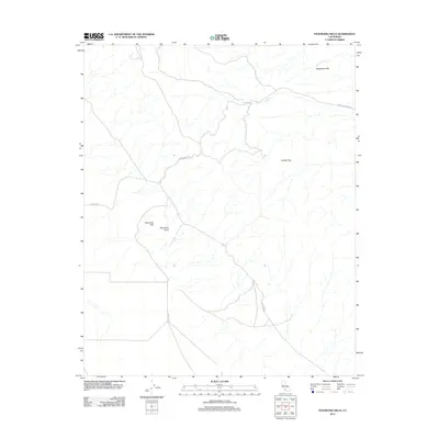
2012 Map of Panorama Hills
USGS Topo · Published 2012About this map
The Panorama Hills and Panorama Point dominate this 2012 study of the high western edges of the San Joaquin Valley in Kern County. This arid landscape is defined by its topographic extremes and sparse water sources, such as the isolated Crocker Spring. The drainage of Buena Vista Cr cuts through the northern portion of the terrain, while the Telephone Hills rise to the northeast. Human passage through this high country is marked by a network of remote corridors including Hurricane Rd and Crocker Springs Rd, tracing routes across the open expanse of Crocker Flat. The map illustrates a region where ranching or resource roads provide the only infrastructure within a complex system of ridges and seasonal watercourses.
Find a feature on this map
10 named features on this map. Tap any name to fly to it.
Don’t see what you’re looking for? This feature index may not catch every label — zoom into the map to look around manually.
Map Details
Editions of this 2012 Panorama Hills Map
This is the sole edition of this map. No revisions or reprints were ever made.
Other maps of this area

1912 · McKittrick
USGS Topo · 1:125,000

1932 · West Elk Hills
USGS Topo · 1:31,680

1941 · Caliente Mountain
USGS Topo · 1:62,500

1942 · Caliente Mtn
USGS Topo · 1:62,500

1943 · Simmler
USGS Topo · 1:62,500

1943 · Caliente Mtn.
USGS Topo · 1:62,500

1944 · Panorama Hills
USGS Topo · 1:31,680
1944 · Fellows
USGS Topo · 1:31,680
1944 · Elkhorn Hills
USGS Topo · 1:31,680
1944 · Midway Peak SW
USGS Topo · 1:31,680